
What Comes Next
We have now passed our original departure date from Mexico. A ship is going to pick up and carry Eventide north to Victoria, British Columbia. This ship carries boats and is doing a run from Florida to Canada with a few stops in between. Its name is AAL Gibraltar and as I write this it’s sitting anchored off the north / east side of Panama Canal waiting for its transit.

That little yellow dot represents the ship that will pick up Eventide in a few weeks
Our time in Mexico has extended by at least two weeks and I believe when all is said and done, it will be more like 4 weeks. This business of boat shipping is a modern marvel, but isn’t one that runs on a super set schedule. It goes when the ship is full and adds / removes stops based on demand. Being a ship, it is subject to the constraints all ships face – congestion in canals and weather altering course or sailing dates.
Speaking of weather, it’s like June 15th came and the tropical kitchen turned on. Storms in this eastern part of the Pacific form off off Central America. They start out as unsettled weather exiting land and, if the conditions are right, form into lows that can grow into storms or hurricanes. It is very early in the season, but the water this year is much warmer than usual.

Surface Sea Temperature (SST) anomaly chart for June 26, 2023. Red means it is hotter than usual. There is a lot of red where we are.
GFS wind model for western Mexico from June 27th for 7 days
All this warm water provides the fuel for storms and the National Hurricane Center is tracking two lows that are starting to form. As of right now, these are not forecasted to become tropical storms but watching them has made us realize we are in a new season.

National Hurricane Center’s Tropical Weather outlook for the Eastern Pacific from 11 AM PDT on June 27th
Update! As we wrote this, the first storm had become a Tropical Storm and will likely become a hurricane tomorrow. It is well south of us and will very likely stay this way (the track has the center about 10 degrees of latitude south). A very cool. but geeky aside. There are not weather buoys floating in this part of the world and not that many flights that would go through the storm. This makes it hard to know how strong the storm actually is - how fast the wind is. Wind speed is a key determining factor in whether something is a low, storm, or hurricane. To understand what’s actually going on, NOAA uses a satellite to determine wind speed and direction. From space, we can tell how fast the winds are in almost any part of the ocean! It isn’t a real time feed of data, but close enough to be very useful. You can read more here.

The updated outlook with Tropical Storm Adrian called out.
The local temperature already told us this. It’s warm. Water is solidly in the mid-80s. The air is in the 90s during the day and barely dips into the high 80s at night. We are sleeping all over the boat and working to stay hydrated late into the night. We have been treated to fantastic skies with edge-to-edge Milky Way as we lay gently sweating on the back deck.

The temperature in our cockpit yesterday. Peaked around 99F late yesterday afternoon, cooled off to mid-80s until the winds came off the desert around midnight, when it came back up to 89F till the desert winds abated. And then it spiked as the sun rose.
NOAA and the NWS have a ton of increíble information and forecasts available. Given how frequently we check them, we pulled them all together into one page here. This pulls the latest of a number of graphics and text forecasts that the National Hurricane Center produces. This is a tremendous example of how great public expenditure improves the lives of many people. While forecasting is in exact, the amount of data available an the analysis of it is a tremendous public service. We are fortunate that this investment has been made and that all of the data is freely available. In many countries the data simply doesn’t exist and, even if it does, is not made freely available.
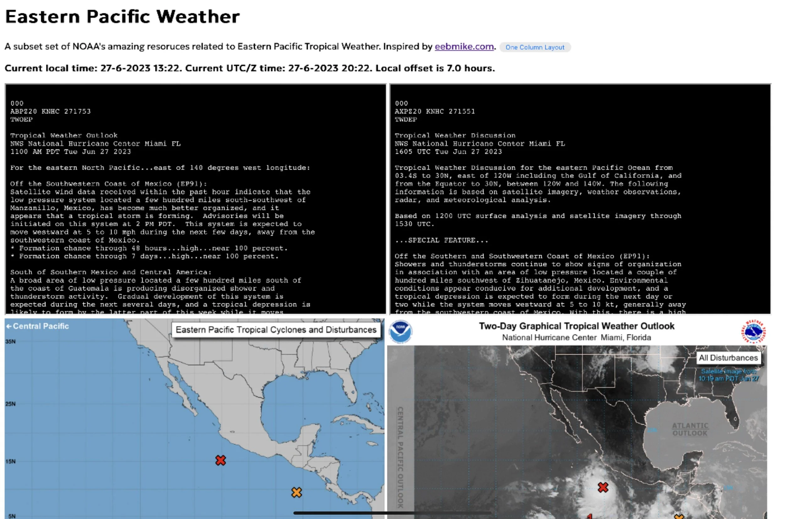
The simple page we put together to aggregate NOAA resources.
We are going to enjoy our time left. We are now steadily making progress south, bashing into the southerly winds that are now present during the day and seeking shelter from the strong westerlies that blow off the Baja at night. It is a different sort of cruising, but an incredible experience nonetheless.